
Upgraded signs sprouting all over
Info-packed signage points the way to a safer park.
What do sunbleached letters, questionable hardware, and confusing directions have in common? All three have been standout features of China Camp’s long-past-their prime trail signs.
Fear not: Friends of China Camp’s intrepid volunteers and partners have once again come to the rescue, designing new, informative, easy-to-understand signs to help keep our visitors safe and heading in the right direction.
Efforts have been solidly endorsed by the community, with Giving Marin Community Partnership recently awarding our nonprofit with a $5,000 grant to help fund the signage project. (Big congrats to the 13 other Marin-based nonprofits who also received Giving Marin grants.)
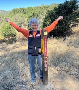
To appreciate and understand the Herculean task of overhauling all of China Camp’s signs—at trailheads, junctions, the village and visitor center, and at park boundaries, we turned to Joyce Abrams, project lead and FOCC volunteer coordinator. Once the project got underway, Joyce’s home office became “sign central,” with neat piles of sorted signs carpeting the floor. Here, Joyce unravels all the steps required to make this long-needed upgrade a reality:
FOCC: How long have you and other volunteers been working on this project, and why did it need to be done?
We began in October 2020, so 2½ years ago. The old signs were faded, unstable, and either lacking important information or altogether inaccurate. So there was a very big need to replace them. It was a chance for us to provide better information and make the park safer and more inviting for our visitors. Nobody wants to get lost in the park.
FOCC: How did you get the project rolling?
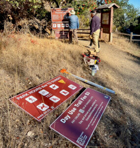
First, we created a committee to help design the new signs and figure out what they needed to say, and where we needed to put them. It was a big task, since it wasn’t one-size-fits-all. We had all different kinds of signs for different needs—on trails, in the campground, at our scenic areas and the village. It was a big task. We realized it made the most sense to focus on one type of signage for this first project, which aims to replace trail posts marked with trail information, as well as large informational signs at trailheads. We’ll tackle other park signage with future projects.
FOCC: Where did funding come from for this project?
Great question. FOCC Executive Director Martin Lowenstein did an outstanding job raising awareness about the project, and he spearheaded a special fundraising drive. (Big thanks to everyone who donated!) Without these funds, this project would not have happened.
FOCC: How did you decide on a design?
We liked the new, icon-driven signage used in the Marin County Open Space preserves and other nearby parks, so we figured we didn’t need to recreate the wheel. So we used that design as a starting point. Next, we needed (and got) project approval from the California Department of Parks and Recreation.
FOCC: What are “emergency locator numbers” and how do they make the park safer?
The numbers, marked in black on a small yellow circle, correspond to the emergency services map used by the local emergency dispatch system. When a visitor calls 911 for help, he or she can report the closest emergency locator number, which will help first responders get to the scene as quickly as possible. We worked closely with the San Rafael Fire Department to determine signage that would provide the best information.
FOCC: Any other new features that you’re excited about?
Yes! The new trailhead signs also include QR codes that you can scan with your mobile phone to access a “You are here” map, as well as a QR code to pay your trail fee—you don’t need to find a pay station somewhere else in the park.
FOCC: What were the steps needed for actually replacing signage?
First, we needed to measure the exact distances between trail heads, intersections, and points of interest. That way we could accurately update our signs that tell visitors distances between point A to B. To do that, we measured all of the trails in the park to 1/100 of a mile. (FOCC comment: Joyce downplays this step—she literally walked countless miles with a measuring wheel to accurately document distances.) Then our maintenance volunteers and staff stepped in, removing old signs and posts, digging holes, pouring cement, and mounting new signs.
FOCC: Did the team have surprises along the way?
For one, we were surprised by the number of trail signs and posts. It wasn’t until we started the process that we realized that there were dozens and dozens of outdated or confusing signs all over the park. We especially liked finding the ones with speed limits for mountain bikers, with the note “Speed checked by radar” at the bottom. We’re not sure if that was ever done, but FOCC certainly doesn’t use radar guns.
FOCC: Where does the project stand now?
The trailhead and trail post signage is 99 percent completed but there’s still quite a lot to do. We’ve come a long, long way, and we’re so excited to take such a big step in making the park safer and easier to navigate.
—by Harriot Manley
 Special thanks to the following people and organizations who have made this project possible:
- FOCC Signage Committee & maintenance volunteers
- San Rafael Fire Department
- FastSigns of San Rafael
- El Cerrito Mountain Biking Team
- All those who donated during our fundraisers